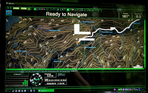
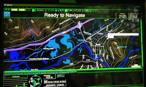
Ever since I flipped through my first ever Backroad Mapbook, I've hoped that its publishers would release those maps for use in my Garmin GPS. Their Digital Edition CD's were a move in the right direction. With those map images, I could load them into mapping software such as OziExplorer or Fugawi, which made them very useful at home, or in the woods...as long as I had my laptop or netbook computer with me. But now, at long last, they've released their Backroad GPS Maps which load directly into my Garmin GPS. Was it worth the wait? Spoiler alert: OH YEAH!
Backroad Mapbooks produces a few different products in their Backroad GPS Maps line. The one I reviewed is the British Columbia SD version. This version comes pre-loaded on a 2gb SD card, and covers all of British Columbia. At a price of CAD$150, I know the first question some of you will ask is why is it so much more expensive than Garmin's Topo Canada product. Topo Canada, which covers all of Canada, costs CAD$99. The difference, quite simply, comes down to the level of detail. In all the locations where I've compared Backroad Mapbooks' product against Garmin's Topo Canada, the latter has consistently showed greater detail and in a more much easily-viewed format. It's very obvious that Topo Canada is built on old topographic data.
Backroads GPS map / Garmin released
-
jessef

- Posts: 6459
- Joined: Tue Feb 26, 2008 1:27 pm
- Vehicle: JDM flavour of the month
- Location: Vancouver
- Location: Vancouver, BC
Backroads GPS map / Garmin released
http://www.bc4x4.com/pr/2010/backroad-gps-maps/
-
thelazygreenfox
- Posts: 904
- Joined: Tue Jun 08, 2010 7:21 am
- Member's Photo Album: http://www.delica.ca/Photos/
- Vehicle: 99 white Hi roof gas Chamonix
- Location: Coquitlam B.C.
- Location: coquitlam canada
Re: Backroads GPS map / Garmin released
It's a great product and rich in detail as JF says. BMB works well with Metroguide Canada and North America NT, switching to the different maps easily. I'm waiting for the upgrades due later this year showing the new Fraser crossings and other features as well.
Ask for the BMB to be loaded on to a 2 GB chip so you can combine North America NT with it. This allows for one chip only to be used in the unit. Switching chips and carrying extra chips is a bother. Their techies loaded BMB to a 2GB chip, reluctantly, after initial software problems but I highly recomend the products they offer.
Look for a second hand Garmin Handheld rather than buying retail. Craigs List and Ebay have good offers.
TLGF
Wear your mask, it keeps others from seeing the parsley in your teeth
-
Artacoma
- Posts: 569
- Joined: Sat Mar 31, 2007 1:51 pm
- Member's Photo Album: http://www.delica.ca/Photos/
- Vehicle: 97 V6 LWB
- Location: Victoria BC
- Location: Victoria BC
Re: Backroads GPS map / Garmin released
hmmm ............ wonder if my in dash nav (Kenwood with garmin gps) can absorb fresh some fresh mapping....... off to google land for me........
Rik
97 Series 2 V6 LWB
97 Series 2 V6 LWB
-
delicat

- Posts: 2331
- Joined: Thu Jul 26, 2007 6:26 pm
- Member's Photo Album: http://www.delica.ca/Photos/
- Vehicle: '92 Exeed '93 Safari '94 Pajero
- Location: New Westminster, BC
- Location: New Westminster, BC
Re: Backroads GPS map / Garmin released
Another option is also about to be made available. Handheld GPS with SPOT application (Satellite tech.)
http://forum.ih8mud.com/ca-bc-coastal-c ... cator.html
Not sure how much would be the SPOT monthly fees but it'd be nice to know you can text or send a SOS from any remote location you might find yourself...
http://forum.ih8mud.com/ca-bc-coastal-c ... cator.html
Not sure how much would be the SPOT monthly fees but it'd be nice to know you can text or send a SOS from any remote location you might find yourself...
'93 Nissan Patrol
'94 Mitsubishi Pajero
"If it ain't broken, modify it!"
'94 Mitsubishi Pajero
"If it ain't broken, modify it!"
-
sasquatch-hunter

- Posts: 620
- Joined: Sat Sep 01, 2007 8:56 am
- Member's Photo Album: http://www.delica.ca/Photos/
- Vehicle: 2 Delica
- Location: Quesnel BC
- Location: Quesnel BC
- Contact:
Re: Backroads GPS map / Garmin released
Cool, now I can get lost!

Re: Backroads GPS map / Garmin released
Has anyone bought this package yet? If so I'd like them to check to see if the road system they show is similar to the updated Anglers Atlas version of Google maps. They appear to show roads that don't exist similar to what the Tourism BC does. Sounds like it would be a good buy even with roads that don't exist. I can give examples if interested.
Larry
Larry
-
cobsweb
- Posts: 84
- Joined: Sun Jul 05, 2009 8:48 pm
- Member's Photo Album: http://www.delica.ca/Photos/
- Vehicle: 92 Exceed
- Location: Vancouver Island
Re: Backroads GPS map / Garmin released
downloaded the free Ibycus canada TOPO maps from a torrent.
its a 3.6 Gb open source mapset compiled from government topo maps
works great with my garmin 76csx
http://www.ibycus.com/ibycustopo/
we're using version 2.1, however version 3 is available.
cheers colby
its a 3.6 Gb open source mapset compiled from government topo maps
works great with my garmin 76csx
http://www.ibycus.com/ibycustopo/
we're using version 2.1, however version 3 is available.
cheers colby
-
strada-caster
- Posts: 260
- Joined: Mon Feb 16, 2009 11:17 pm
- Member's Photo Album: http://www.delica.ca/Photos/
- Vehicle: Mitsubishi Strada 1992
- Location: Thunder Bay, Ont
- Location: Thunder Bay, Ontario
Re: Backroads GPS map / Garmin released
I'm using the same ibycus (i think the same version) free topo maps on a garmin c60csx
they are decent (especially when you factor in the FREE part), but one glance at my hardcopy BMB (where i can see a FSR road easily compared to a topo line) and I want that on my GPS. probably gonna get it, Just haven't yet. I'd love to ba able to zoom in on my Backroads map book.
they are decent (especially when you factor in the FREE part), but one glance at my hardcopy BMB (where i can see a FSR road easily compared to a topo line) and I want that on my GPS. probably gonna get it, Just haven't yet. I'd love to ba able to zoom in on my Backroads map book.
Re: Backroads GPS map / Garmin released
Anybody with info or comments since June?
-
FalcoColumbarius

- Site Admin
- Posts: 5983
- Joined: Tue Jan 22, 2008 1:55 pm
- Member's Photo Album: http://www.delica.ca/Photos/index.php?cat=11103
- Vehicle: Delica; Chamonix GLX ('92 P25W)
- Location: North Van, BC, eh?
Re: Backroads GPS map / Garmin released
I still like my Garmin PC Mobile married with Topo Maps. I have an issue of Mussio Ventures "Digital Edition" that is designed to go with OziExplorer & Fugawi, I just found it complicated and expensive to operate. I got Topo Maps, which is put out by Garmin and married the programmes together with a free download called "Nroute". I paid $120.00 for the whole of Canada, I think I paid $40 for the Backroads disc and it only covered southern BC. I find Topo really convenient to read and easy to manipulate, it works for me...
Regarding roads in the bush: Apart from the forest mains ~ they tend to change from season to season, i.e.; one year it might be a big road, the next year it might be totally grown over. As far as navigation goes: I will much sooner go by the creeks than depend on the roads still being there.
Falco.
Sent from my smart pad, using a pen.
Seek Beauty... Good Ship Miss Lil' Bitchi
...... Vision without action is a daydream. Action without vision is a nightmare. ~ Japanese Proverb
Seek Beauty...
Good Ship Miss Lil' Bitchi...... Vision without action is a daydream. Action without vision is a nightmare. ~ Japanese Proverb
-
Profister

- Posts: 963
- Joined: Fri Feb 08, 2008 3:41 pm
- Member's Photo Album: http://www.delica.ca/Photos/
- Vehicle: 1999 PE8W Chamonix, EFI
- Location: North Vancouver, BC
Re: Backroads GPS map / Garmin released
Just FYI: nRoute is not available for a year or so already and the latest MapSource does not do routing. I am not sure where Garmin is going with these 'updates'.
http://www.laptopgpsworld.com/1827-nrou ... ble-garmin
http://www.laptopgpsworld.com/1827-nrou ... ble-garmin

-
Paule
- Posts: 94
- Joined: Sat Feb 07, 2009 1:52 pm
- Member's Photo Album: http://www.delica.ca/Photos/
- Vehicle: 1997 L300 Active World
- Location: New West
Re: Backroads GPS map / Garmin released
I picked this up for my Garmin 260W gps. I was really pumped to finally see these solid books available for my gps.
A few things I was/am disappointed with:
It does not appear on the gps screen as it does in the books. The impression I got from looking at the box was that it would appear the same. This may be the case for the handheld trekking units.
It has a ton of detail, perhaps too much. As you zoom in to see the road you're on, the elevation lines become too busy and make it difficult to glance quickly at the map and know clearly where your next move is... However, I have only tried it in the valley bottoms of the Squamish/Whistler/Hope areas. Up in the interior I would expect that the absence of dramatic elevation changes would make it a bit easier to interpret. (I say interpret because it often takes a bit of time to tell if you are on a road or an elevation line)
Overall it is pretty cool, and I can't wait to put it to a real test on a long road trip. But it isn't something that I would solely rely on if I were out in the wilderness.
pe
-
FalcoColumbarius
- Site Admin
- Posts: 5983
- Joined: Tue Jan 22, 2008 1:55 pm
- Member's Photo Album: http://www.delica.ca/Photos/index.php?cat=11103
- Vehicle: Delica; Chamonix GLX ('92 P25W)
- Location: North Van, BC, eh?
Re: Backroads GPS map / Garmin released
I found this, it's current:
http://www8.garmin.com/support/agree.jsp?id=575
If you "proceed to the download page" there are a number of feeds worth looking at.
As far as up dating the roads goes ~ one can never keep on top of that, the status of a bush road can change dramatically within one season. As I stated previously, when navigating in the bush I will typically use waterways as landmarks rather than roads ~ creeks, rivers, lakes, &c., don't move as much. Does anyone remember when we went to the West Harrison system back in '08 and we looked at our brand new Backroads books and we decided to take the Hail Creek Road? The books were new, data was maybe two years old and the Hail Creek Road was a thick black line. When we got there the thick black line turned out to be a creek bed. At one time this was a road but not any more, yet the Backroads book said it was. Things change in the bush and you should consider that when you are forking out your hundred odd bucks on the latest GPS system ~ by the time you buy it, it is likely out of date. As far as updates are concerned, they are fine for major public highways such as the TC1, &c., but the road needs to be reported in order to be updated. When an FSR is deactivated it isn't necessarily reported to the mapping companies and might end up being posted on the maps as something that it is not.
Another system that has been brought to my attention is "Centrafuse". I know next to nothing about this system but it looks interesting. Is anyone up on Centrafuse?
Falco.
Sent from my smart pad, using a pen.
Seek Beauty... Good Ship Miss Lil' Bitchi
...... Vision without action is a daydream. Action without vision is a nightmare. ~ Japanese Proverb
Seek Beauty...
Good Ship Miss Lil' Bitchi...... Vision without action is a daydream. Action without vision is a nightmare. ~ Japanese Proverb
-
Profister
- Posts: 963
- Joined: Fri Feb 08, 2008 3:41 pm
- Member's Photo Album: http://www.delica.ca/Photos/
- Vehicle: 1999 PE8W Chamonix, EFI
- Location: North Vancouver, BC
Re: Backroads GPS map / Garmin released
The complete nRoute software collection is available for download here.
-
almac

- Posts: 717
- Joined: Mon Jul 06, 2009 1:29 am
- Member's Photo Album: http://www.delica.ca/Photos/
- Vehicle: '91 Delica "Tessen"
- Location: Okanagan
- Location: Okanagan, BC CANADA
Re: Backroads GPS map / Garmin released
i think gpss' are cool, but i don't think they are very accurate.
for example, i used my garmin csx to drive from route1 via canada way to tardis hotel.
the gps told me to turn left, then right onto route1; i turned left onto a dead end street.
and no, the dead end street was like that for many many years... it wasnt a new addition.
makes me wonder how accurate they really are.
Roads!? Who the hell needs roads!?,
al

91' Delica "Tessen", 5spd, RS9000XLs, camperized.
al
91' Delica "Tessen", 5spd, RS9000XLs, camperized.